![](/images/other/stat-length.png)
![Excursión Senderismo La Londe - La Londe vers le pont d](https://media.geolcdn.com/t/1900/400/42cb85ee-c651-4847-898a-7100674070ab.jpg&format=pjpeg&maxdim=2)
La Londe vers le pont d"Orléans
MichelRando7656
Usuario
![Longitud](/images/other/stat-length.png)
Longitud
12,4 km
![Altitud máxima](https://static1.geolcdn.com/siteimages/upload/files/1508320355ic_sort_altitude_max_24dp.png)
Altitud máxima
133 m
![Desnivel positivo](https://static1.geolcdn.com/siteimages/upload/files/1508320355ic_sort_den_pos_24dp.png)
Desnivel positivo
234 m
![Km-Effort](/images/other/stat-length.png)
Km-Effort
15,5 km
![Altitud mínima](https://static1.geolcdn.com/siteimages/upload/files/1508320355ic_sort_altitude_min_24dp.png)
Altitud mínima
41 m
![Desnivel negativo](https://static1.geolcdn.com/siteimages/upload/files/1508320355ic_sort_den_neg_24dp.png)
Desnivel negativo
234 m
![Boucle](https://static1.geolcdn.com/siteimages/upload/files/16400158638029165_repeat_loop_refresh_sync_direction_icon.png)
Boucle
Sí
Fecha de creación :
2021-07-03 11:34:47.937
Última modificación :
2021-07-03 16:57:45.031
![Senderismo](https://static1.geolcdn.com/sitytour/trail-icons/101.png)
4h25
Dificultad : Difícil
![Escanee este código QR para abrir la excursión en la aplicación SityTrail](https://capi.geolives.com/qq0zvz2zws4bq2lad0pu/sitytour/trails/2848378/qr.png?size=200)
Aplicación GPS de excursión GRATIS
A propósito
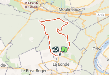
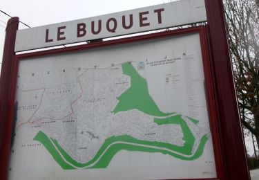
Ruta Senderismo de 12,4 km a descubrir en Normandía, Sena-Marítimo, La Londe. Esta ruta ha sido propuesta por MichelRando7656.
Descripción
Beau parcours très varié. De belles côtes et des descentes rapides. En cas de pluie, prévoir les batons. Très bonnes chaussures de randonnées nécessaires.
Fotos
"
data-pinterest-text="Pin it"
data-tweet-text="share on twitter"
data-facebook-share-url="https://www.sitytrail.com/es/trails/2848378-la-londe--la-londe-vers-le-pont-dxorleans/?photo=0#lg=1&slide=0"
data-twitter-share-url="https://www.sitytrail.com/es/trails/2848378-la-londe--la-londe-vers-le-pont-dxorleans/?photo=0#lg=1&slide=0"
data-googleplus-share-url="https://www.sitytrail.com/es/trails/2848378-la-londe--la-londe-vers-le-pont-dxorleans/?photo=0#lg=1&slide=0"
data-pinterest-share-url="https://www.sitytrail.com/es/trails/2848378-la-londe--la-londe-vers-le-pont-dxorleans/?photo=0#lg=1&slide=0">
"
data-pinterest-text="Pin it"
data-tweet-text="share on twitter"
data-facebook-share-url="https://www.sitytrail.com/es/trails/2848378-la-londe--la-londe-vers-le-pont-dxorleans/?photo=1#lg=1&slide=1"
data-twitter-share-url="https://www.sitytrail.com/es/trails/2848378-la-londe--la-londe-vers-le-pont-dxorleans/?photo=1#lg=1&slide=1"
data-googleplus-share-url="https://www.sitytrail.com/es/trails/2848378-la-londe--la-londe-vers-le-pont-dxorleans/?photo=1#lg=1&slide=1"
data-pinterest-share-url="https://www.sitytrail.com/es/trails/2848378-la-londe--la-londe-vers-le-pont-dxorleans/?photo=1#lg=1&slide=1">
"
data-pinterest-text="Pin it"
data-tweet-text="share on twitter"
data-facebook-share-url="https://www.sitytrail.com/es/trails/2848378-la-londe--la-londe-vers-le-pont-dxorleans/?photo=2#lg=1&slide=2"
data-twitter-share-url="https://www.sitytrail.com/es/trails/2848378-la-londe--la-londe-vers-le-pont-dxorleans/?photo=2#lg=1&slide=2"
data-googleplus-share-url="https://www.sitytrail.com/es/trails/2848378-la-londe--la-londe-vers-le-pont-dxorleans/?photo=2#lg=1&slide=2"
data-pinterest-share-url="https://www.sitytrail.com/es/trails/2848378-la-londe--la-londe-vers-le-pont-dxorleans/?photo=2#lg=1&slide=2">
"
data-pinterest-text="Pin it"
data-tweet-text="share on twitter"
data-facebook-share-url="https://www.sitytrail.com/es/trails/2848378-la-londe--la-londe-vers-le-pont-dxorleans/?photo=3#lg=1&slide=3"
data-twitter-share-url="https://www.sitytrail.com/es/trails/2848378-la-londe--la-londe-vers-le-pont-dxorleans/?photo=3#lg=1&slide=3"
data-googleplus-share-url="https://www.sitytrail.com/es/trails/2848378-la-londe--la-londe-vers-le-pont-dxorleans/?photo=3#lg=1&slide=3"
data-pinterest-share-url="https://www.sitytrail.com/es/trails/2848378-la-londe--la-londe-vers-le-pont-dxorleans/?photo=3#lg=1&slide=3">
![Excursión Senderismo La Londe - La Londe vers le pont d Excursión Senderismo La Londe - La Londe vers le pont d](https://media.geolcdn.com/t/170/100/42cb85ee-c651-4847-898a-7100674070ab.jpg&format=jpg&maxdim=2)
![Excursión Senderismo La Londe - La Londe vers le pont d Excursión Senderismo La Londe - La Londe vers le pont d](https://media.geolcdn.com/t/170/100/d46eb655-0014-4440-9a27-5ef737884793.jpg&format=jpg&maxdim=2)
![Excursión Senderismo La Londe - La Londe vers le pont d Excursión Senderismo La Londe - La Londe vers le pont d](https://media.geolcdn.com/t/170/100/3b6bd9ad-e49b-4c18-b4b8-117c925f20f1.jpg&format=jpg&maxdim=2)
![Excursión Senderismo La Londe - La Londe vers le pont d Excursión Senderismo La Londe - La Londe vers le pont d](https://media.geolcdn.com/t/170/100/083a7489-2748-44c0-8a43-e1c15b5fbeb1.jpg&format=jpg&maxdim=2)
Localización
País:
France
Región :
Normandía
Departamento/provincia :
Sena-Marítimo
Municipio :
La Londe
Localidad:
Unknown
Salida:(Dec)
Salida:(UTM)
351288 ; 5463568 (31U) N.
Comentarios
Excursiones cerca
![Excursión Senderismo Caudebec-lès-Elbeuf - Caudebec-les- Elbeuf 12km - Photo](https://media.geolcdn.com/t/375/260/ff911e05-9d04-4aef-af60-0d3d13a09c7b.jpg&format=jpg&maxdim=2)
![Senderismo Senderismo](https://static1.geolcdn.com/sitytour/trail-icons/101.png)
Caudebec-les- Elbeuf 12km
Senderismo
Medio
(1)
Caudebec-lès-Elbeuf,
Normandía,
Sena-Marítimo,
France
![](/images/other/stat-length.png)
10,7 km | 13,8 km-effort
3h 56min
![](https://static1.geolcdn.com/siteimages/upload/files/16400158638029165_repeat_loop_refresh_sync_direction_icon.png)
Sí
![Excursión Senderismo La Londe - La Londe 76- 13 km - Photo](https://media.geolcdn.com/t/375/260/23588b19-2689-475f-b2bd-10608cbf7253.jpg&format=jpg&maxdim=2)
![Senderismo Senderismo](https://static1.geolcdn.com/sitytour/trail-icons/101.png)
La Londe 76- 13 km
Senderismo
Difícil
(1)
La Londe,
Normandía,
Sena-Marítimo,
France
![](/images/other/stat-length.png)
13 km | 16,1 km-effort
3h 43min
![](https://static1.geolcdn.com/siteimages/upload/files/16400158638029165_repeat_loop_refresh_sync_direction_icon.png)
Sí
![Excursión Senderismo Caudebec-lès-Elbeuf - Caudebec les Elbeuf vers saint Cyr la campagne - Photo](https://media.geolcdn.com/t/375/260/ext.jpg?maxdim=2&url=https%3A%2F%2Fservices.sitytrail.com%2FGeolivesWS%2FDownloadMedia.ashx%3FTrailID%3D985245%26Media%3Dfix__20180531102544.jpg)
![Senderismo Senderismo](https://static1.geolcdn.com/sitytour/trail-icons/101.png)
Caudebec les Elbeuf vers saint Cyr la campagne
Senderismo
Medio
(2)
Caudebec-lès-Elbeuf,
Normandía,
Sena-Marítimo,
France
![](/images/other/stat-length.png)
12 km | 15,2 km-effort
3h 7min
![](https://static1.geolcdn.com/siteimages/upload/files/16400158638029165_repeat_loop_refresh_sync_direction_icon.png)
Sí
![Excursión Senderismo Moulineaux - Robert-le-Diable - château - GD - V2 - Photo](https://media.geolcdn.com/t/375/260/ext.jpg?maxdim=2&url=https%3A%2F%2Fstatic1.geolcdn.com%2Fsiteimages%2Fupload%2Ffiles%2F1553511878bg_sport_marche.png)
![Senderismo Senderismo](https://static1.geolcdn.com/sitytour/trail-icons/101.png)
Robert-le-Diable - château - GD - V2
Senderismo
Difícil
(1)
Moulineaux,
Normandía,
Sena-Marítimo,
France
![](/images/other/stat-length.png)
10,4 km | 13,1 km-effort
2h 58min
![](https://static1.geolcdn.com/siteimages/upload/files/16400158638029165_repeat_loop_refresh_sync_direction_icon.png)
Sí
![Senderismo Senderismo](https://static1.geolcdn.com/sitytour/trail-icons/101.png)
20240507-La Londe Cool
Senderismo
Fácil
La Londe,
Normandía,
Sena-Marítimo,
France
![](/images/other/stat-length.png)
7,3 km | 9,2 km-effort
2h 15min
![](https://static1.geolcdn.com/siteimages/upload/files/16400158638029165_repeat_loop_refresh_sync_direction_icon.png)
Sí
![Excursión Senderismo Elbeuf - elbeuf/chemin du halage - Photo](https://media.geolcdn.com/t/375/260/538ff371-2c24-4bd6-b0ae-2b3d8c404d65.jpg&format=jpg&maxdim=2)
![Senderismo Senderismo](https://static1.geolcdn.com/sitytour/trail-icons/101.png)
elbeuf/chemin du halage
Senderismo
Muy fácil
(1)
Elbeuf,
Normandía,
Sena-Marítimo,
France
![](/images/other/stat-length.png)
7,9 km | 8,6 km-effort
1h 35min
![](https://static1.geolcdn.com/siteimages/upload/files/16400158638029165_repeat_loop_refresh_sync_direction_icon.png)
Sí
![Senderismo Senderismo](https://static1.geolcdn.com/sitytour/trail-icons/101.png)
la londe
Senderismo
Difícil
La Londe,
Normandía,
Sena-Marítimo,
France
![](/images/other/stat-length.png)
11,6 km | 14,3 km-effort
3h 14min
![](https://static1.geolcdn.com/siteimages/upload/files/16400158638029165_repeat_loop_refresh_sync_direction_icon.png)
No
![Excursión Senderismo La Bouille - La Bouille- Cote Albert Lambert-Robert le Diable - Photo](https://media.geolcdn.com/t/375/260/6619d219-dc7a-4ef0-85ef-d79a78fa0fb8.jpg&format=jpg&maxdim=2)
![Senderismo Senderismo](https://static1.geolcdn.com/sitytour/trail-icons/101.png)
La Bouille- Cote Albert Lambert-Robert le Diable
Senderismo
Difícil
La Bouille,
Normandía,
Sena-Marítimo,
France
![](/images/other/stat-length.png)
14,9 km | 18,8 km-effort
4h 23min
![](https://static1.geolcdn.com/siteimages/upload/files/16400158638029165_repeat_loop_refresh_sync_direction_icon.png)
Sí
![Senderismo Senderismo](https://static1.geolcdn.com/sitytour/trail-icons/101.png)
20240312-La londe cool
Senderismo
Fácil
(1)
La Londe,
Normandía,
Sena-Marítimo,
France
![](/images/other/stat-length.png)
7,7 km | 8,9 km-effort
2h 7min
![](https://static1.geolcdn.com/siteimages/upload/files/16400158638029165_repeat_loop_refresh_sync_direction_icon.png)
Sí